
Most people think of Langley as flat farmland. But the reality is a glacially shaped landscape of rolling hills, ancient river corridors, 11 major watersheds, and hundreds of kilometres of living creeks. We went below the surface to understand the ground Langley actually sits on, and talked to a local surveyor who reads this land for a living.
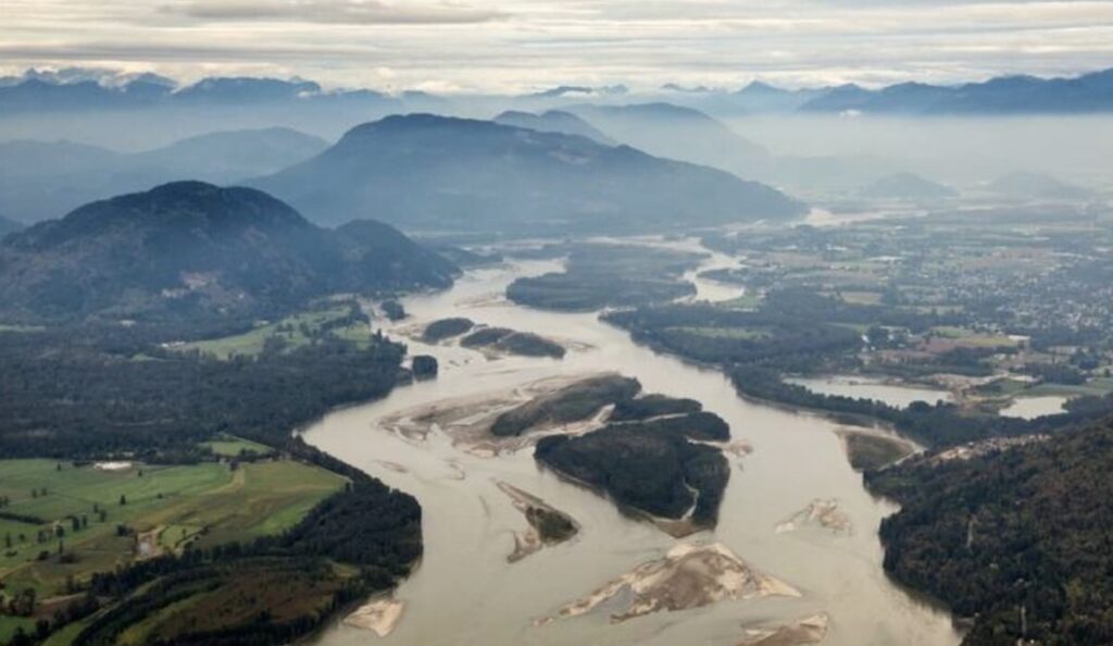
Langley is not flat. That surprises a lot of people. Drive south from the freeway on 200th Street and you descend, noticeably, from the elevated Willoughby plateau down into the Nicomekl River corridor. Head west from Aldergrove toward Murrayville and you move across a series of low, rounded hills separated by creek valleys. Climb toward Fort Langley from the south and the road rises steadily toward the Fraser River bluffs, where the view opens up across the valley all the way to the North Shore mountains. Langley’s terrain is subtle by BC standards, but it is real, and once you start paying attention to it, you can’t stop seeing it everywhere.
The landscape of Langley is the product of glaciation. Ten to fifteen thousand years ago, the entire Fraser Valley sat under a sheet of ice thousands of metres thick. As that ice retreated, it left behind a deeply shaped terrain of glacial till, drumlins, moraines, outwash plains, and river valleys carved by meltwater and then reshaped over millennia by the rivers and creeks that still run through the Township today. The result is a landscape that looks deceptively simple from a car window but is, geographically speaking, one of the most complex and water-rich areas in the Lower Mainland.
The Willoughby Slope: Langley’s Most Dramatic Terrain
If you want to understand Langley’s topography, start at the Willoughby Slope. This elevated ridge in the northeast of the Township is where the land rises most noticeably above the surrounding floodplains, giving the area its name and its distinctive character. The Slope drops away to the south toward the Nicomekl floodplain and to the north toward the Fraser River lowlands, and on a clear day the views from the higher elevations here take in mountains in every direction.
It is not a coincidence that Willoughby became the Township’s primary growth area. The elevated, well-drained ground was naturally suited to residential development in ways that the low-lying floodplains to the south were not. But that elevation also means complex terrain for anyone trying to build on it. The slope creates drainage challenges, requires careful grading, and means that understanding the precise elevation and contours of any given parcel can be the difference between a successful build and an expensive mistake.
The Rivers That Define Langley
More than any other geographic feature, it is Langley’s rivers and creeks that shape its identity. The Township sits within a remarkable network of waterways that run in nearly every direction, carrying water from the hills and ridges down to the Fraser River, to Boundary Bay, to Mud Bay, and across the international border into the United States.
The Nicomekl River
The Nicomekl is Langley’s most significant river in terms of everyday life. It runs roughly east to west, forming a natural corridor that separates the higher terrain of the Willoughby Slope from the farmland of south Langley. With a total length of 34 kilometres and a drainage area of approximately 42.8 square kilometres, the Nicomekl collects water from much of central Langley, passing through the City of Langley and continuing west through Surrey before draining into Mud Bay at Blackie Spit.
The name Nicomekl comes from the Halq’emeylem language of the Stó:lō people, meaning “the route to go” or “the pathway.” It was a genuine route. For centuries, Indigenous peoples paddled up the Nicomekl and portaged across to the Salmon River, using this waterway system as a highway through the Fraser Valley. The European fur trade followed the same path. When James McMillan’s HBC survey party arrived in 1824, one of the things that struck them was how navigable the Nicomekl was compared to other nearby rivers.
Today the Nicomekl is both a wildlife corridor and a flood risk. The river’s floodplain is one of the most productive agricultural areas in Langley, but it also floods regularly during heavy rain, and the low-lying properties near the river see the consequences every wet winter. The watershed includes Murray Creek and Anderson Creek as major tributaries, and supports a remarkably diverse range of fish including coho, chum, chinook and pink salmon, steelhead, rainbow trout, and several species of lamprey.
The Salmon River
The Salmon River is, by many measures, Langley’s most ecologically extraordinary waterway. It flows northwest through the Township before entering the Bedford Channel near Fort Langley, and it carries one of the last remaining healthy runs of wild coho salmon in the entire Metro Vancouver area. That is not a small thing. Wild coho have essentially disappeared from most Lower Mainland rivers due to urbanization and habitat loss. The Salmon River still has them, and researchers consider it one of the most productive rivers for its size in all of British Columbia for wild coho.
The Salmon River watershed drains approximately 76.9 square kilometres and includes several major tributaries: Coghlan Creek, Davidson Creek, Otter Creek, and Union Creek. At least 13 species of fish live in the river, including the endangered Salish Sucker, which exists in very few places anywhere. The river is also one of the most studied in BC, and was the subject of a formal Watershed Management Plan in the 1990s.
The Salmon River’s heritage goes beyond ecology. For thousands of years, it was the primary trade and travel route through the Fraser Valley. First Nations peoples canoed up the river, portaged through the Milner area near what is now Glover Road, and then followed the Nicomekl out to Mud Bay and the coast. The portage area was known as the Tsalkwakyan. When James McMillan established Fort Langley in 1827, he did so at the junction of the Salmon and the Fraser because that convergence had been a centre for trade and gathering for millenia before any European set foot here.
The Little Campbell River
The Little Campbell River drains the southern edge of the Township, running more than 30 kilometres through five different jurisdictions before discharging into Boundary Bay through a tidal estuary. Its headwaters are in Langley, and a large portion of its watershed sits within the Agricultural Land Reserve. The river supports wild populations of coho, chinook, chum, and steelhead salmon, as well as cutthroat trout, and is home to several species at risk including the Salish Sucker and the Nooksack Dace.
The Little Campbell also has a distinctive characteristic: it crosses the international border. Portions of the watershed extend into Washington State, making stewardship of this river literally a cross-border affair. The Little Campbell Watershed Society works across both Canadian and American jurisdictions to protect and restore habitat in the basin.
Bertrand Creek
Bertrand Creek originates in Aldergrove and flows south into the Nooksack River Basin in Washington State. It is one of Langley’s smallest watersheds but one of its most ecologically sensitive, providing critical habitat for the endangered Nooksack Dace and Salish Sucker and hosting spawning grounds for coho salmon. Because Bertrand Creek flows across the international border, enhancement and conservation work here has implications beyond the Township’s boundaries.
The Hills and Ridges You Might Not Have Noticed
Langley’s topographic relief is not dramatic in the way that the mountains of North Vancouver are dramatic. But it is real and consequential. The Township’s average elevation is around 47 metres, but individual properties and neighbourhoods vary significantly. The Willoughby Slope climbs well above the valley floor. The Brookswood area sits on its own elevated plateau separated from the Nicomekl lowlands to the north by a noticeable escarpment. Fort Langley perches on a bluff above the Fraser River, which is part of what made the site so attractive for a trading post, the high ground gave both visibility and defensibility.
The rolling terrain of south Langley, particularly around Campbell Valley and the area south of 8th Avenue, reflects the original glacial drumlin topography. Drumlins are elongated hills formed directly by glacier movement, and they appear throughout the Fraser Valley. In Langley they give the landscape its characteristic gently rounded ridges and hollows, where water collects in natural wetland depressions between the higher ground.
What This Means When You’re Surveying the Land
John MacMillan has been reading the land of the Fraser Valley for most of his professional career. As a surveyor with Abbotsford Surveyor Services, he works on property boundary surveys, topographic surveys, and land subdivision work across the region, including throughout Langley Township. The terrain he encounters is rarely as simple as it looks from the road.
John points out that surveying in Langley frequently involves navigating the intersection of topography and regulation. ALR boundaries, floodplain development permits, riparian setbacks along creeks and rivers, drainage covenants, these all layer on top of the physical terrain in ways that require careful measurement and documentation.
“The riparian setbacks alone can significantly effect what’s buildable on a property,” he says. “Any property within a certain distance of a stream or river in BC is subject to setback requirements that protect the stream habitat. In Langley, with as many creeks and streams as there are, that affects a lot of parcels. People buy land and don’t always realize that a small creek running through the back corner of the property changes what they can legally do near it.”
He also talks about the challenges that come with Langley’s rapid development, particularly in areas like Willoughby where the pace of construction has changed the land in ways that affect drainage and hydrology across whole neighbourhoods.
“When you pave a hillside you change where the water goes. Langley has added a huge amount of impervious surface over the last 20 years in the northern part of the Township, and that has downstream consequences for the creeks and wetlands lower in the watershed. Surveyors and engineers who understand the original topography of those areas can see the relationship between what was built and what’s happening now with drainage and flooding. It’s all connected.”
What the Water Tells You
One of the most revealing things about Langley’s topography is how the water behaves. The Langley Environmental Partners Society has documented that the community has 11 major watersheds and hundreds of kilometres of streams. Those streams are not just ecological resources. They are the land’s drainage infrastructure, the system that the terrain was built around over thousands of years, and that development activity has been constantly negotiating with since the first farms were cleared in the 1800s.
In November, if you walk the trails at Williams Park along the Salmon River, you can watch coho salmon spawning in water so clear you can count the fish. In spring, the Nicomekl lagoon near 53rd Avenue in Langley City fills with migratory waterfowl following the river corridor north. In winter, the low-lying farm properties along the Nicomekl floodplain sometimes disappear under water entirely after a sustained atmospheric river. These are not separate phenomena. They are all expressions of the same underlying geography, the same hills and valleys and creek systems that were laid down by ice and water long before anyone thought to build anything here.
Understanding that geography is not just an academic exercise. It matters for where houses can be built and where they shouldn’t be. It matters for which roads flood and which don’t. It matters for whether the salmon come back or don’t. And it matters for the farmers who have been reading this land’s water behaviour across generations and who understand, better than most people, what the terrain is actually telling them.
